We had an 8 mile downhill to kick off the day so I wore all of my riding clothes anticipating some nasty wind chill. Good plan. With the exception of some frigid fingertips, it was a reasonably comfortable ride into the town of Walker, CA.
We found a small market that was closed and as we were checking it out for potential water sources (i.e. a hose), a fellow pulled up to deliver some mail. He let us know that there were a coffee shop and larger market just down the road and both were open.
We found the coffee shop first and were happy to see that it had our favorite on the road amenity, wi-fi. Amazingly, U also had phone service for the first time in weeks so I tried to call home. All I was able to do was leave a message but it was nice just the same. We spent about an hour having coffee and catching up. When it was time to leave, it was as if we had entered another climate entirely. The sun was out and it was hot. All the extra clothes came off and sunscreen went on. What a difference an hour makes. We filled up on water and headed out.

Coffee, wi-fi, and a magic climate changer
Just down the road we saw Randy coming out of the market. We usually get started before him but since we often stop for things like wi-fi and he doesn't, he usually catches up. He had missed the coffee shop but had found his needed groceries and we all left town together.
Today's route map called for a climb over Monitor Pass between Topaz Lake and Woodfords. This was to be the steepest and longest climb of the trip. I was not looking forward to it. Neither was Randy. It has been a topic of discussion for the last several days along with the possibility of detouring around it. The adventure cycling maps are great for showing our route and about a mile on either side of it. For anything else (including detours) they kind of suck. I am carrying a full map of California but it doesn't have enough detail to plan a detour. Fortunately we have had our favorite amenity at a few places recently and I have plotted (via google maps) a route around the pass of pain. It is about 8 miles longer but the hope was that the climbing would be less severe.
As a bonus, the detour also makes this 3 state trip into a 4 state trip. We headed off into Nevada on our detour.

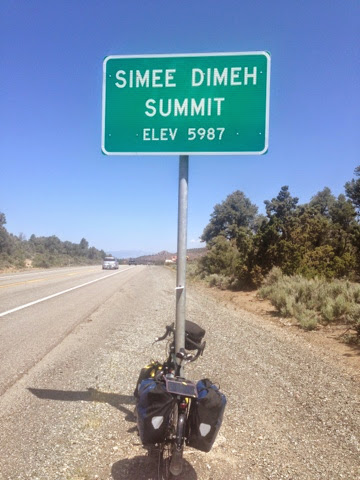
Not just a new county but an entirely different state!
The ride around the pass turned out to be a pretty good day of riding. There was some climbing but it was not bad. Nothing like the original route.
Yeah, it's lower but you still have to climb to the top of it.
We have been collecting pictures at summits and various elevation points along the route. Randy has been laughing about this as he doesn't stop very often at all. We had ridden ahead of him after crossing the state line but he passed us again when we stopped for an early lunch. That is how he came to be ahead of us as we approached the summit of the climb. I saw him stopped by the summit sign with his bike and I thought that he had been converted. Turns out he was just stopping to leave us a note. The little paper taped to the pole in the picture above says "5987ft. Big Deal". He isn't converted, he is just a smart ass.
I could tell we had entered a different state. The was noticeable evidence along the road: a casino just across the state line, more broken beer bottles along the shoulder, and apparently smarter cows.

Watch out for the smart cows, they've out there
We continued our detour down into a valley (always something you have to climb back out of) and found our turn. It was at a 7-11 so I stopped for a cold drink and double checked the directions.
We rode west across the valley and back south along the base of some pretty tall mountains. Soon the headwind and the climb started. It was also the point that our sojourn into Nevada came to an end. We had gone backwards and were now back in California.

I thought we were done with this state.
It was a bit of a slog out of the valley and down into Woodfords. It is always odd when your eyes are telling you you are going downhill and your legs are telling you it is uphill. The magic of the headwind.
Our campground is 5 miles out of Woodfords. This gives us a start on the long climb over Luther Pass into Lake Tahoe tomorrow.
We are staying at another RV park (a but more primitive than the last one) that is right across the road from a USFS campground. Since we started traveling with Randy, our camping has become more economical which allows us some luxuries. At 65, he gets a senior discount at National Park, Forest Service, and several other facilities. That has cut our base camping fees in half, but we then split that three ways. What that means is that we could have stayed across the road without him for $10 each or we can all stay here together for $4 each. The $4 site has water and showers, the site across the road does not. The shower was long, hot, and great!

Shower house eggs
As a bonus, there is a little store/cafe adjacent to (but unaffiliated with) the campground. Yes, that means wi-fi!
It looks like tonight will be another cold one. We'll try to get going early and get up over the pass before it gets windy. We are going to try for a long day again tomorrow to get up close to Truckee north of Tahoe.
Having violated the golden touring blog rule (don't finish until the day is over), I am now editing to add the first long distance bikers we have seen in our campground since we picked up Randy. Seth and Niel rolled up as I was finishing up. They are on the Western Express route and just finished their first 100 mile day. They started in central Nebraska and will finish in San Francisco in a few days. We gave them some tips about the campsites and showers and of course the all important wi-fi (they were most excited about that).

Welcome to camp guys
No comments:
Post a Comment